Investigating History – Japanese Airfields at Clark & Tarlac Air Center
MABALACAT EAST AIRFIELD UNDER AERIAL ATTACK, NOVEMBER 19, 1944 – 1944 年 11 月 19 日、マバラカット東彦城でのアメリカ軍の空襲
INVESTIGATING HISTORY SERIES – WWII AIRFIELDS CLARK-TARLAC AREA – クラーク地域の日本軍飛行場の調査
Our region of Clark-Bamban-Tarlac is a WWII historical locality, where Filipinos, Americans and Japanese forces were based and engaged in the epoch of history. Among the subjects of WWII History in our area are the airfields used during WWII, both by the Americans and the Japanese. Most of these airfields now, especially those constructed and used by the Japanese Navy and Army air forces are forgotten. It should be that necessary steps to be taken somehow to document and present historical narratives of these airfields since the history also covered the history and struggle of the soldiers from the 3 countries involved. In this juncture, we are devoting a part of our research and publication of the WWII Airfields of Clark and Tarlac region, as part of our Investigating History WWII Series.
MABALACAT EAST AIRFIELD – マバラカット東飛行場
From where I am based at the Bamban WWII Museum, the nearest WWII airfield, in fact, is not our Bamban Airfield but the nearby Mabalacat East Airfield, a mere 3.5 kilometers to the south, the Mabalacat East Airfield. This Japanese air strip, part of the Clark Air Center that was built by the Japanese, was mostly used by the Imperial Japanese Navy Air Service, but there were also some units from the Arny Air Service.

Allied Geographical Section SW Pacific Area,
Terrain Handbook 40 Cabanatuan Central Luzon Philippine Series.
RUNWAY NO. 2 – 飛行場2番
The Mabalacat East Airfield, also designated as Mabalacat Runway No. 2, was in the barrio of Cacutud, Mabalacat. The barrio itself was utilized as part of the airfield, where aircraft were camouflaged and hidden from among the houses along the only street. During WWII, the barrio was militarized with the presence of the Japanese facilities, as fuel, ammunition and supply dumps and warehouses were constructed and established inside the barrio.
HISTORY OF MABALACAT EAST AIRFIELD – マバラカット東飛行場の歴史
As with the most Japanese air strips outside of the Clark proper, Mabalacat East Airfield was constructed in late 1943 and early 1944 and became operational in 1944 until the middle of January 1945. Although based on aerial photographic images shows a define air strip on the right side of the barrio or village taken in 1944, several maps indicated that there was a “V” shaped runway, although it can be concluded that the area on the right of the village and right of the national highway coming from Mabalacat which was fairly level cleared area was used as runway, with a 4,593 x 984 feet on a east – west orientation., all-weather with 20-inch rock base, sand, clay and shell surface that used to be agricultural fields during pre-war period. The area was a flat sugar cane land, with several patches of bamboos in the barrio that even to these days, can still be found.
")
BUNKERS AND PILLBOXES – 飛行場のコンクリート製の兵員シェルター施設
North and south of the airfield can be found clamps of bamboos, as in the village of Iba (north) and the barrio of Atlu Bola. A small stream traversed from the west-east direction on the left of the barrio, where numerous concrete bunkers and pillboxes were constructed and used by the Japanese. These bunkers and pillboxes are evident on aerial photographs taken by the U.S. Navy carrier-borne aircraft. Left of the airstrip is now part of the Policarpio Marina Golf Club (now closed).

TAXIWAYS AND REVETMETNS – 航空機隠蔽施設
Taxiway and revetments areas were around the airfield, and the right side of the barrio were aircraft, single and twin-engine aircraft can be seen based on November 1944 aerial photographs available. On the west of the national highway (now MacArthur) highway, on what is now part of Barangay Dolores, Mabalacat, were constructed of aircraft revetments made of compacted soil. More than 10 aircraft revetments were constructed and used in 1944 located to the west of present Barangay Dolores, or left of the Mabalacat East Airfield. After the war, all these revetments were bulldozed and destroyed to make room for the sugar cane fields, and none I think, exists today. There were several building facilities constructed on the middle right of the barrio Cacutud that may be used as soldiers barracks or maintenance facility. Roads were constructed around the air strip for transportation of supplies and military materiel.

ANTI-AIRCRAFT GUNS – 対空砲
By November 1944, the Japanese begun improving the anti-aircraft defenses of the airfields at the Clark Air Center, from Bamban to Mabalacat, the Clark proper, Angeles and Porac. In one of the aerial photographs of the Mabalacat East taken on November 19, 1944, there were anti-aircraft batteries located within the airfield premises:
Anti-aircraft gun batteries around Mabalacat East Airfield, late 1944:
(1) 200 meters on the right of the barrio and 300 meters from the present MacArthur Highway (on the right side coming from Mabalacat City), were high concentration of anti-aircraft guns, a battery-size. Aerial photograph taken in November 5, 1944 by aircraft from U.S.S. Hornet (CV12) indicates that there were around 12-gun emplacements. With the numerous air raids conducted in November, by the 19th, there were only 4-5 anti-aircraft guns left in the area, as shown on aerial photograph taken on that day. The area is now the SCTEX headquarters.
(2) Near the Iba Road, about 500-600 meters to the right of the air strip and 300 meters on from the National Road, was another concentration of anti-aircraft guns, mostly 75mm, as the aerial photograph taken during the bombing by the carrier-borne aircraft form U.S.S. Hornet.
(3) About 500-600 meters on the edge (southeast) of the barrio Cacutud, on the right side of the main road, there were about 10 anti-aircraft gun emplacements appearing on aerial photographs taken on November 19, 1944 air raid.
There were other smaller gun emplacements surrounding the airfields, but these were destroyed by the massive air campaigns conducted by the carrier-borne fighters, torpedo-bombers and navy bombers by the U.S. Navy’s Task Force 38 in the last quarter of 1944.

JAPANESE NAVY AIR FORCE UNITS
At some point in the operational status of the Mabalacat East Airfield, there were aircraft from the Imperial Japanese Navy 1st and 2nd Air Fleet that operated from the airfield, including both the Navy and the Army’s Kamikaze Special Attack Forces:
Imperial Japanese Navy’s air units (including Kamikaze units) at Mabalacat Airfields, last quarter of 1944:
201 Kokutai (Air Group)
252 Kaigun Kokutai (Air Group)
701 Kaigun Kokutai (Air Group)
221 Kaigun Kokutai (Air Group)
The Japanese Imperial Army (4th Air Army) 72nd Air Regiment, with Hayate fighters (Type 4), was mobilized and stationed in the late 1944 at the Mabalacat East Airfield, with some pilots became Army Kamikaze special attack with the Seika Unit.
THE KAMIKAZE SPECIAL ATTACK – 神風特別攻撃
The two Mabalacat Airfields (east and west) became the basements for the Japanese Navy’s Special Attack or Kamikaze. The 201 Kokutai (201 Air Group), 1st Air Fleet became the core unit of the Imperial Japanese Navy Special Attack, based at Mabalacat Airfields. The first successful Special Attack took off on October 25, 1944 at Mabalacat East Airfield, led by Lt. Yukio Seki of the Shikishima-tai. The beginning and the end of the Japanese Navy’s Kamikaze Special Attack was at the Mabalacat; the first ceremony taken place at the edge of Mabalacat West Airfield, the sortie on the first successful Kamikaze on East Airfield and the last Kamikaze took off from the Mabalacat Airfield mostly from Kongo Unit. Many of the pilots from other Air Groups of the Japanese Navy in Clark Air Center were transferred to the 201 Kokutai, where they took-off their last flight as Kamikaze pilots.
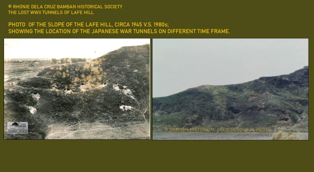
OKAMOTO AIRFIELD BATTALION – 岡本飛行場大隊
On the identification of the airfield battalion in charge for the security and maintenance of the airfield, it was probable that the Okamoto Butai, belonging to the 132nd Airfield Battalion under the command of Major Okamoto, was based at the Mabalacat East Airfield. Official records from the Kembu Group sourced from the Japan National Institute for Defense Studies – Tokyo shows the basements of the airfield battalion and companies in the Clark Airfield and that the Okamoto Butai (132nd AF Bn) was later moved to nearby Lafe Hill, in command of the defenses of that hill overlooking the Xevera site and the Mabalacat City College. The distance from Mabalacat East Airfield to Lafe Hill is approximately 2 kilometers, making it the nearest place of deployment in the Kembu Group north sector of this airfield battalion.
THE AERIAL PHOTOGRAPH, NOVEMBER 19, 1944 – 日本海軍航空隊と神風特攻隊
One of the numerous aerial photographs taken of the Mabalacat East Airfield by the carrier-borne aircrafts of the U.S. Navy’s Task Force 38 (some carriers were the U.S.S. Yorktown, Hornet, Wasp, Cowpens and Monterey) particularly the U.S.S. Yorktown on November 19, 1945 which shows the actual explosions at the airfield with the air raid, where the ammunition and supply dumps were taken direct hit. This is the single aerial photograph taken by the aircraft from the U.S.S. Yorktown, which conducted massive aerial reconnaissance of the airfields from Clark, Mabalacat, to Tarlac on the same day.
AIR RAID FROM AMERICAN CARRIER U.S.S. YORKTOWN – アメリカの空母ヨークタウンからの空襲
On that day, the U.S. Navy 3rd Fleet, Carrier Division 3, Task Force 38.1 carried a massive air campaign on Japanese airfields and other facilities in Central Luzon. The U.S.S. Yorktown was committed for the campaign on the day, with sent off 4 Grumman F6F (night fighters), 46 F6F, 18 Grumman TBM Avengers and 24 SB2C navy bombers for the mission with targets around Clark Air Center and Tarlac. Some of these aircraft were allocated to conduct air raids and fighter sweeps on Japanese targets at the Mabalacat East Airfield with mission to destroy aircraft.
DIRECT HITS ON THE MABALACAT EAST – マバラカット飛行場が破壊された
On that day of operations, there were no Japanese air interception on marauding American navy aircrafts. American piltos however, had very difficulty in finding Japanese aircraft targets on the ground, since many of these were hidden from under the native houses in the barrio, some under the bamboo thickets and others were camouflaged.

American carrier-borne aircraft from Yorktown scored direct hits on the Japanese ammunition and supply dumps, as well as hitting barracks and buildings at the Mabalacat East Airfields on that day. 7 single-engine aircraft were also caught on the ground and were destroyed by the fighter sweeps. Large and heavy black smoke billowed from the center of barrio of Cacutud, where it was believed that an ammunition and fuel supply dumps were hit during the air raid.
AMERICAN AVIATORS LOSSES – アメリカ人パイロットの損失
The raid on Mabalacat East Airfield on November 19, 1944 that is the subject of the aerial photograph being presented here, was not without a loss to the American aviators. Three (3) American pilots gave their lives on the day’s operation from U.S.S Yorktown alone, with Lt. T.A. Bacchus (USNR), crashed and his aircraft exploded during the air strike which was hit by one of the anti-aircraft guns at Mabalacat East. Ensign N.S. Lotz (USNR) was last seen during the air strike at Mabalacat East Airfield, possibly due to anti-aircraft fire.

There are still many stories of struggles in WWII, and this single photograph taken on the raid by the aircraft of the U.S.S Yorktown tells a fraction of that forgotten history.
Rhonie Dela Cruz
Bamban Historical Society
Bamban WWII Museum
Center for Pacific War Studies
Provincial Government of Tarlac –
Tarlac Provincial Tourism Office
Citation:
(1) USS Yorktown Operation Against Enemy Airfields in Central Philippines, November 19, 1945, Report No. CV10/A16-3(1) Serial 0258, November 23, 1944, NARA.
(2) US Pacific Fleet, Commander Division Three, Attacks on Luzon Objectives, 19 November 1944, Report No. FB2-3/A16-3, November 29, 1944, NARA.
(3) Allied Geographical Section SW Pacific Area, Terrain Handbook 40 Cabanatuan Central Luzon Philippine Series “Section – 2 C2-Mabalacat East”.
(4) Photograph Clark Field Area – Mabalacat, November 4, 1944 by CV12, No. 22/57, NARA.
(5) Moji Chikanori, At the Far End Between the Sky and the Sea – Reminiscences of the First Air Fleet Adjutant, translated.
(6) Records of the Kembu Group Fighting Chronicles, translated by Jin Arai and Takashi Fukuda, National Institute for Defense Studies, Tokyo, Japan.
Photograph:
(1) “PLANE DISPERSAL AND CAMOUFLAGE – MABALACAT”: Main photograph is the Mabalacat East Airfield, bombed by the aircraft from USS Yorktown on November 19, 1944; Report No. FB2-3/A16-3, November 29, 1944, NARA.
(2) Other photographs show specific areas of the airfield to identify the facilities, anti-aircraft guns and batteries, locations of revetments and bunkers or pillboxes around the airfield. All other photographs, except the map, were taken from this single aerial photograph to highlight facilities of the airfield.
(3) Mabalacat West, Mabalacat East, Clark North and Clark Airfields, Pampanga, September 21, 1944, Allied Geographical Section SW Pacific Area, Terrain Handbook 40 Cabanatuan Central Luzon Philippine Series.